
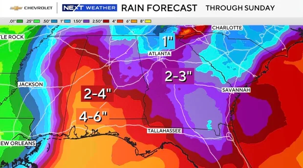
Metro Atlanta is bracing for a weekend of severe weather as Hurricane Isaias officially strengthened into a Category 1 storm late Wednesday night, putting North Georgia directly in its path.
Forecasters warn that the storm is expected to intensify into a Category 2 hurricane before making landfall along the northern Gulf Coast late Friday or early Saturday. Because the Atlanta metropolitan area sits on the dangerous eastern side of the system, local meteorologists have issued a widespread Weather Impact Alert for Saturday.
The primary hazards for the region include:
Torrential Rainfall: Widespread accumulations of 2 to 3 inches of rain are projected across metro counties between Friday night and Sunday, raising serious flash flooding concerns.
Damaging Winds: Wind gusts reaching 40 to 50 mph are expected to sweep through the area. Because regional soils are already heavily saturated, these tropical-storm-force gusts could easily topple trees and trigger widespread power outages.
Spin-Up Tornadoes: The storm’s outer rainbands bring a high risk of brief, fast-moving tornadoes that can form with little to no advance warning.
Beyond localized infrastructure threats, the hurricane is also complicating regional travel. Severe weather is expected to impact major corridors between Georgia and Alabama, threatening travel plans for thousands of sports fans heading to Tuscaloosa for the highly anticipated college football matchup between the Georgia Bulldogs and the Alabama Crimson Tide.
Emergency management officials urge residents to finalize household preparations by Friday afternoon. Authorities recommend charging all essential devices, clearing neighborhood storm drains, and ensuring multiple ways to receive severe weather alerts throughout the weekend.
Critical Storm Preparation Checklist
Residents should complete all home and safety preparations before outer bands arrive Friday evening:
Power & Lighting: Fully charge all cell phones, laptops, and portable power banks by Thursday night. Prepare flashlights or LED lanterns (avoid candles due to fire risks during high winds).
Food & Water Storage: Stock at least 1 gallon of water per person per day for 3 days. Purchase non-perishable, ready-to-eat foods that don’t require cooking. Fill clean bathtubs with water to use for flushing toilets if municipal water pressure drops.
Property & Patio Security: Bring loose, lightweight outdoor objects inside, such as patio furniture, trash cans, and potted plants. Secure rain gutters and clear debris from storm drains to prevent localized water pooling.
Safe Zone Identification: Know your home’s interior tornado safe zone—ideally a windowless, central room on the lowest level (such as a closet or bathroom).
Communications: Turn off “Silent” mode on mobile devices overnight to ensure you hear automated severe weather alerts. Download the FOX 5 Storm Team App or the WSB-TV Weather App or keep track of your weather at Accuweather for real-time tracking.
Check This Out...
-
Six Flags Over Georgia Re-Opens Days After 42 Year Old Atlanta Teacher Died In Tragic Accident: Six Flags Faces Growing Scrutiny, Questions Over Ride Safety: Park President Issues Statement
-
Longtime Fox 5 ‘Good Day Atlanta’ Anchor, Former Atlanta Braves Star Ron Gant Leaving The Station: Gant Has Hosted Show For 14 Years, Says He Doesn’t Plan To Leave Atlanta
-
Bill Water Advisory Lifted For 5 Five South Fulton Cities: Atlanta Watershed Management Announced The Advisory Several Days Ago
-
Man Dies At 6 Flags Over Georgia After Fall From Roller Coaster; Four Injured: “Goliath” Ride Is 200 Feet High, Hits Speeds Of Up To 70 MPH
-
Hurricane Isaias Leaves Downed Trees, Flooding, And Thousands Without Power Across Southeast, Metro Atlanta: At Least 2 Confirmed Dead